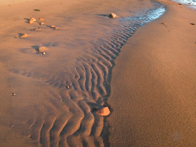
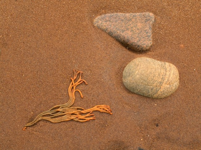
Here are four close-up studies of shells found at low tide on the south side of Napeague Harbor. I like to think of these images as fractions of the larger landscape – scenes which are found in abundance on any beach that has not been visited by tires. Unfortunately a passion for recording of such details is generally not recognized in beach driving debates.
During the last four summers we vacationed in southern Utah, a place more famous for massive canyon walls than trickling desert streams. But the two sometimes combine to make a hike in arid country far more refreshing than you might expect.
In Capitol Reef National Park we’ve followed stream beds for an entire day. In nearby Escalante, Pine Creek is another place to do this. The creeks in canyon country are generally shallow and often flow across naked rock for miles. In some spots they pass through slickrock gorges that are so narrow that the trail essentially becomes the stream. Before venturing into any of these places, one needs to check the weather because sudden downpours can produce flash floods.
Surprisingly, even in mid summer the water in the streams is frigid. We’ve taken hikes in August where you’re either wet and shivering or baking in temperatures that approach 100 degrees. It all depends on whether or not you’re in the water. Get yourself wet and your teeth chatter. Hike back into the sun and you open the oven door.
Hiking Sulphur Creek in Capitol Reef involves so many stream crossings that you can’t keep track of them. After a half a mile or so, any hope of dry boots is squashed. The easiest thing to do is simply get in the stream and stay there. There are sandals designed for this. There are also a number of waterfalls passing over rock chutes that require careful navigation. Because the canyon walls rise hundreds of feet in these places, you either find a way to climb through the pour-offs or turn around and go back. You have two choices for many of these hikes – either get wet or completely soaked.
Aside from enjoying the water, I always get out the camera. The images I’m looking for are in the cloistered places where the creek plunges into the shade of canyon walls. It’s here that I’ve found the most compelling reflections. When studying the way the water looks from a variety of angles, you sometimes find pockets of irresistible color. In the shade, reflections of rocks, leaves and sky become deeply saturated.
It’s been in these sequestered locations where I’ve found many of my favorite pictures. It’s no coincidence that they’re also some of my favorite places.
This is is a sequence of four images from various points around the perimeter of Napeague Harbor. There’s a number of ways to group these, but in this instance I’ve arranged them vertically to convey something of what you might find at your feet during a walk on the beach. I like to think of these images as petite landscapes – photographs close to the observer, with most of the elements of the larger picture. Clicking on them will produce an enlargement.
For other sequences from Amagansett and elsewhere go to this link:
Northeast of Capitol Reef National Park in southern Utah is a vast wild area– a complex of eroded sandstone landscapes known as the San Rafael Swell. For those impressed with numbers, the area occupied by the San Rafael (pronounced Rah-FELL) is approximately one million acres. By way of analogy, it’s about the same size as Long Island where I live– but unlike our Island, the Swell is not home to several million people. There are generally more canyons here than conversations, and you will sometimes encounter more rattlesnakes than visitors. Its seemingly endless array of stony washes, hoodoos, slickrock and isolated pools can be difficult to describe and sometimes hard to photograph with any justice. We’ve hiked and camped the Swell so often, I’ve lost track of how many times I’ve been there.
Anywhere else in the country the San Rafael would’ve been declared a National Park or Monument years ago. But in Utah (a state not lacking anything spectacular) the affairs of the Swell have fallen largely into the hands of the Department of the Interior’s Bureau of Land Management. There are several wilderness study areas under consideration, but the BLM (in case you haven’t heard) has had the occasional affair with mining, off-road vehicle interests and gas exploration. Currently, the Swell exists with both ongoing threats and a growing push to create a National Monument. For those motivated toward preservation, The Southern Utah Wilderness Alliance (SUWA) is the principle group trying to save the place. http://www.suwa.org/site/PageServer
This past summer, we made several day trips in from Hanksville or Green River. In the silence and heat that can transform a summer’s stroll on slickrock into something that’s really gotten your attention, the camera can be a playful device to bring to that awareness.
On these hikes it was random passing stuff that stopped me. The look of a rock or a stick — the tread across sandstone. Textures and color — hidden corners of big places — the small things in a huge landscape.
In the canyons I collect details like I used to collect postage stamps when I was a kid. Back home I sort through the photographs and see how they look in groups. Once in awhile when sequencing pictures like this something comes together. I settle on an arrangement of three:
A Cottonwood leaf… polka dots raindrops on a rock… a dry image of lichens.
I’ve been working on a project which involves grouping compatible images into sequences. This began a few years ago with a series I called “Dune Studies” –seen here:
Last summer while on vacation in Utah, the idea gained momentum. We were taking hikes each day, often following streams in canyons. On these walks, I was photographing water reflections, rocks and lichens- all subjects that were easily found a few feet away.
At home, I began sorting through these pictures along with others shot on local beaches during similar walks. I found that if you assemble a group of three or four images, the results can suggest the movement of both time and space experienced during a walk.
Over the last few months I’ve put together 8 sequences of either three or four pictures each. I made two groups from last summer’s Utah trip- one of lichens and another of creeks. All the rest of the photographs were taken on beaches in East Hampton and Amagansett. In addition to those, I created a series of photographs made on various segments of the Paumanok Path (a 125 mile trail that winds across eastern Long Island). Two of my beach sequences (including the one on this page) are from Napeague Harbor at low tide. This harbor, especially in the vicinity of the Walking Dunes, has striking color and texture:
All of these sequences share characteristics—For one thing, they’re made up of individual photographs of what one might expect to encounter when hiking in a quiet place. But with these pictures I don’t want to convey the larger landscape. This isn’t about distant horizons or dramatic skies. What matters here are the textures and colors of “local” things – subjects found while walking, often no more than ten feet away.
That’s the stepping-off point. Sequencing begins another process.
To do this, it seems to help if you view your project much as a painter might. You dab, so to speak, and you try things out. You play with line and texture. You move things around until it all starts to work.
If you pay attention to your groups you soon have something new. You’ve created a sequence of photographs that is asking to be viewed as a single unit. Its lines, colors, textures are now an integrated whole.
At times, the impressions generated from these sequences can be both refreshing and complex.
More sequences from the beach (and elsewhere) can be seen by clicking here:
")
")
")
")
")
")
")
")
")
")
")
")
")